
Copyright 2007,
James R. Conner,
all rights reserved.
Archives, March – April 2007
I was a college freshman in Houston, Texas, in 1966 when Charles Whitman, an embittered, deranged man, climbed to the top of the clock tower at the University of Texas, in Austin, and started killing students at random with a high powered rifle. I still remember how hard it was to obtain information on the shooting. We had radio, we had television, and, the next day, we had the newspaper.
Today, obtaining information about the shootings at Virginia Tech is not the problem. Cable news stations are carrying the story around the clock, and the internet provides up to the minute written coverage. My problem now is sifting fact from rumor, speculation, and false reports.
One thing, however, has not changed: the out-of-the-blue nature of the event. Murderous rampages by lone gunmen are next to impossible to predict, next to impossible to prevent. After the shootings are over, we learn things about the shooters that, in hindsight, are red flags, but we almost never learn things that can help us predict and prevent the next murderous rampage. Colleges and universities across the nation will review their safety and emergency response programs, sometimes finding and correcting flaws, but there is only an extremely small probability that they will learn something that will prevent more shootings of this genre. The reviews are intended more to protect political backsides than to make campuses safer.
That these lone gunman rampages (the two-man hit team at Columbine was a rare departure from the classic profile) are rare events is the most important fact the public and policy makers should keep in mind. Yes, spree shootings are more frequent than before, but they still are very, very rare. Given we are a nation of 300 million with easy access to firearms, it is surprising to me that more shootings do not occur.
Horrific as the massacre at Virginia Tech was, it falls into the category of fascinating, but, from a public policy standpoint, not terribly important. It will have an emotional impact of some kind on almost everyone, but it will not affect the lives of most Americans in the way that a change in, say, health care policy, can.
The probability that Hungry Horse Dam will fail suddenly and completely is on the order that Kalispell will be wiped out by an asteroid. It could happen, but winning the lottery ten time in a row might be more likely. For that reason, and others, dam managers bristle when reporters ask for a dam’s inundation map to illustrate a story on a dam failure. It strikes them as a stupid question — and, unfortunately, often provokes a stupid answer: "we can’t release that information because of national security." Sometimes, those providing the stupid answer also believe it.
Daily InterLake reporter Kristi Albertson received two of those stupid answers last month, one from the Bureau of Reclamation, which manages HHD, the other from the U.S. Army Corps of Engineers, which manages Libby Dam. She was working on a story (one in the IL’s series on disaster response) on the consequences of a massive breach of HHD, and, logically, wanted to know where the wall of released water would go. The agencies stiffed her, citing security concerns. (Disclosure. I provided Albertson with background information for her story.)
This is rubbish, utterly unworthy of the agencies that built these marvels of engineering.
Where the water would go is not a security concern. It’s a safety concern — and people living in the flood zone have a right to know what would happen. Do public officials really believe that if HHD crumbles after an earthquake, or if terrorists blow up the dam with an atomic bomb, withholding the inundation map will help the people downstream escape the onrushing wall of water? Do officials really think that hiding the map from the people living downstream, and thus supposedly hiding the consequences of a dam failure from terrorists, will make Americans safer because the dam seems to be less inviting a target?
Of course not. But dam officials don’t like talking about dam safety and Tom Clancy genre dam failure scenarios, so when asked, they tend to put their feet in their mouths instead of putting their maps on the table.
More to the point, inundation maps, which can be prepared by any competent hydrological cartographer from data long in the public domain, already exist. Some are online. See, for example, the USAEC’s inundation maps for the Painted Rocks dam in Arizona, which are online because:
Explanation of Maps. The maps indicate the areas which would be flooded under the assumed condition of a dam breach with the reservoir water surface at the spillway crest elevation of 661.0 feet, NGVD [national geodetic vertical datum, functionally equivalent to the height above mean sea level]. Preparation of the maps does not reflect on the safety or integrity of Painted Rock Dam. These maps have prepared as part of a national program to prepare similar maps for all Federal Dams.
Use of Maps. The maps provide a basis for evaluation existing evacuation plans for the affected areas and development of any further plans which are needed. The Corps of Engineers recommends that such evaluation be made and any needed supplemental plans be developed. Information on evacuation planning is available from the Corps of Engineers.
BuRec prepared inundation maps for HHD that local and state emergency services personnel used last year during a tabletop exercise on a postulated dam breach resulting from an earthquake. I obtained a copy of the maps from Governor Schweitzer’s office. Low quality digitized photocopies, they were still useful.
Some years ago, GIS format inundation maps for HHD were available on Flathead County’s FTP website <ftp.co.flathead.mt.us> (use an FTP client application, not your internet browser). They’re gone from that website now, casualties, I suspect, of the post 9/11 anxieties responsible for so much irrational behavior by our public officials, but I downloaded them before they disappeared. Use them at your own risk, but here they are: GIS files, and the approximate inundation boundaries that I imposed on a 1:100k USGS topographic map.
The county’s FTP site has other interesting goodies, among them flood maps from the Federal Emergency Management Agency (FEMA), digitized 1:24k USGS topographic maps for the Flathead, and digitized subdivision plats. One map, ValleyFloor_42X46.pdf (4.1 MB), shows FEMA’s 100-year and 500-year flood plains. Here’s a low resolution copy (PDF 460 KB), but you’ll find the original file more interesting.
Various agencies have mapped floods of the Flathead River in the Flathead Valley. Ten years ago, Flathead County’s Office of Emergency Services (warning: the OES website is woefully out of date) distributed a map on which this annotated Flathead flood map (PDF 593k) (again, use at your own risk) is based. Flood maps were controversial at that time, as some real estate agents of dubious character reportedly were using bogus flood plain maps to conceal from potential buyers the fact that properties were inside the 100-year flood plain. Better maps illustrating various flood stages for the valley undoubtedly are available now, and should be distributed to all residents inside the flood zones along with maps of the best evacuation routes.
Ten years ago, during the snowiest winter in the history of the Flathead, a winter noted for collapsing roofs and backs strained by shoveling tons of the heavy white stuff, those old enough to remember the Flood of 1964 worried that, come spring, the record snowpack would become a record runoff; a runoff that would escape the banks of the Flathead River.
Their fears had foundation — and as day after day of warm, sunny weather followed the equinox, as the rivers swiftly filled, residents of the low lying areas in Evergreen quietly began preparing to evacuate their homes. Meanwhile, crowds gathered at the Old Steel Bridge east of Kalispell to gauge for themselves how high and fast the river was running. It was nothing new, but it was exciting nonetheless.
West of Kalispell, however, in the Ashley Creek drainage, the streams could not contain the tremendous amount of water coming out of the Salish Mountains. By May, Smith Lake was as high as anyone could remember — the fishing access area across from Kila was drowned — and Ashley Creek was out of its banks in every low lying area. On the western edge of Kalispell, the usually well mannered stream had become a lake.
I knew the Ashley flood would be an impressive sight from Lone Pine State Park, so on the morning of 9 May I lugged my tripod and cameras to the park’s overlook to record the event. It was bright, sunny, and warm, a perfect morning for photography. I shot mostly with a 300mm lens, isolating details such as the flooded ball fields by Airport Road. But before packing up my gear, I switched to a 50mm lens, leveled my tripod as best I could, held my focus and exposure constant, and shot a series of overlapping scenes from north to south, covering a 180-degree panoramic sweep of the valley. I had a new slide scanner and reckoned I could convert the slides into a panoramic image.
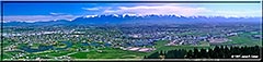 But I made a critical mistake: I used a polarizer to cut the haze and darken the blue of the sky. That made equalizing the density of the individual frames impossible with the software then available to me. I kept working at it over the years, but it was not until Adobe released its beta version of Photoshop CS3 before Christmas, 2006, that I was able to produce a seamless panorama. Click on the small image to the right to bring up a larger image.
I published many of the other images of the Ashley flood, and of the river watchers at the Old Steel Bridge, on my old, and long retired, Flathead Flood & High Water website. Come May, I hope to reprise that exhibit on this website.
Incidentally, the mainstem Flathead River never did drive the residents of Evergreen from their homes. The runoff peaked at 58,200 cubic feet per second on 17 May, which is above flood stage, but receded quickly thanks to a week of cool, dry weather. Had runoff from heavy rains been added to the snowmelt, significant flooding would have resulted.